Watch stunning NASA image of huge ash erupting from Kilauea volcano in Hawaii
Scientists at the US space agency NASA have shared another stunning image of ash erupting from the Kilauea volcano on the Island of Hawaii. As per the reports, the volcano is erupting a large amount of lava in the East Riff which has also lead to high levels of sulfur dioxide in the region forcing people to evacuate the region.
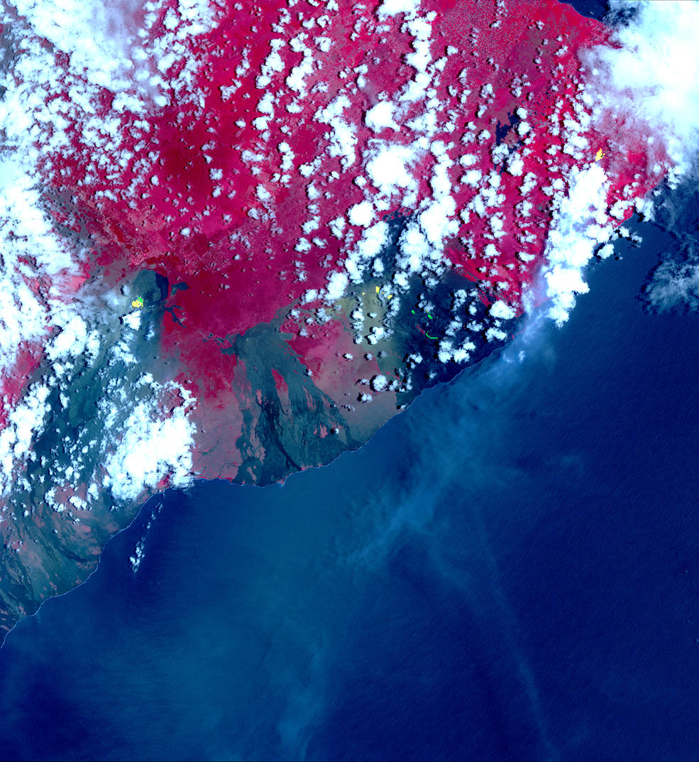
Researchers used the Advanced Spaceborne Thermal Emission and Reflection Radiometer (ASTER) onboard NASA’s Terra satellite to capture the stunning new fissures. In the first image, the red areas are vegetation, and the black and gray areas are old lava flows. The yellow areas superimposed over the image show hot spots that were detected by ASTER’s thermal infrared bands. These hot spots are the newly formed fissures and new lava flow as of May 6. In the second photo, also acquired on May 6, the long yellow and green streaks are plumes of sulfur dioxide gas.
On April 30, the floor of Kilauea’s crater began to collapse. Earthquakes followed, including one that measured magnitude 6.9, and lava was pushed into new underground areas that eventually broke through the ground in such areas as the Leilani Estates.
On May 3, 2018, a new eruption began at a fissure of the Kilauea volcano on the Island of Hawaii. Kilauea is the most active volcano in the world, having erupted almost continuously since 1983. Advancing lava and dangerous sulfur dioxide gas have forced thousands of residents in the neighborhood of Leilani Estates to evacuate. A number of homes have been destroyed, and no one can say how soon the eruption will abate and evacuees can return home.
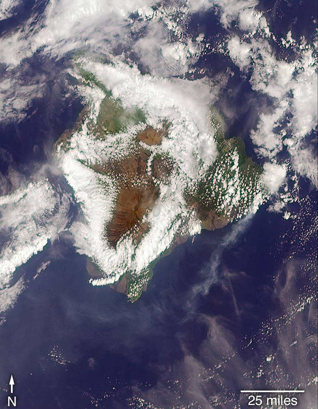
On May 6, 2018, at approximately 11 a.m. local time, the Multi-angle Imaging SpectroRadiometer (MISR) instrument on NASA’s Terra satellite captured this view of the island as it passed overhead. Much of the island was shrouded by clouds, including the fissure on its eastern point. However, an eruption plume is visible streaming southwest over the ocean. The MISR instrument is unique in that it has nine cameras that view Earth at different angles: one pointing downward, four at various angles in the forward direction, and four in the backward direction. This image shows the view from one of MISR’s forward-pointing cameras (60 degrees), which shows the plume more distinctly than the near-vertical views.
The information from the images acquired at different view angles is used to calculate the height of the plume, results of which are superimposed on the right-hand image. The top of the plume near the fissure is at approximately 6,500 feet (2,000 meters) altitude, and the height of the plume decreases as it travels south and west. These relatively low altitudes mean that the ash and sulfur dioxide remained near the ground, which can cause health issues for people on the island downwind of the eruption. The “Ocean View” air quality monitor operated by the Clean Air Branch of the State of Hawaii Department of Health recorded a concentration of 18 μg/m3 of airborne particles less than 2.5 micrometers in diameter at 11 a.m. local time. This amount corresponds to an air quality rating of “moderate” and supports the MISR results indicating that ash was most likely present at ground level on this side of the island.
Kilauea is the youngest and southeastern-most volcano on the island. Eruptive activity along the East Rift Zone has been continuous since 1983. Kilauea is one of the world’s most active volcanoes.
It is the second youngest product of the Hawaiian hotspot and the current eruptive center of the Hawaiian–Emperor seamount chain. Because it lacks topographic prominence and its activities historically coincided with those of Mauna Loa, Kīlauea was once thought to be a satellite of its much larger neighbour. Structurally, Kīlauea has a large, fairly recently formed caldera at its summit and two active rift zones, one extending 125 km (78 mi) east and the other 35 km (22 mi) west, as an active fault of unknown depth moving vertically an average of 2 to 20 mm (0.1 to 0.8 in) per year.
Kīlauea has been erupting nearly continuously since 1983 and has caused considerable property damage, including the destruction of the town of Kalapana in 1990. On May 3, 2018, several lava vents opened in the lower Puna area, downrift from the summit. The new volcanic eruption was accompanied by a strong 6.9 earthquake, and nearly 2,000 residents were evacuated from Leilani Estates. More than 10,000 people were affected. By May 8, 2018 the eruption had destroyed 35 houses in the subdivision.