“Series of Change”: NASA Shares Stunning ‘Before And After’ Images of Earth
NASA knows well how to keep space enthusiasts engaged and engulfed. Previously, the US-based organization has shared numerous spectacular images of space, earth and its views from the skies, clicked by satellites and space probes. However, the recently shared picture of NASA is something different and pretty exciting too. NASA recently shared the 30 years before and after pictures of the earth, which is extremely jaw-dropping. The images are expected to pave more pathways for the researchers to find out the changes and transformations; Earth has come through in last three decades.
The suite of before and after images of the earth is titled under “Series of Change”. The set of pictures is a complete demonstration of how our Mother Planet has evolved over the past 30 years. The series comprises of numerous images, beamed back by the satellite and are depicting everything – from island construction to urbanization to downpour.
In the jaw-dropping set of images, NASA shines the light on the transformation process of the world and its super-fast speed. As shown in the picture, over the last three decades, our Mother Planet has witnessed a number of transformations because of the urbanization and of course, the changes in climatic patterns. The “Series of Change” is also giving clear and perceptible dissimilarities of ecological systems over the last 30 years, as well as pointing out the changes, that earth has come through. While some changes like island construction are caused by the human activities and influences, many are distressed due to the growths in the human population, pollution, and greenhouse gasses.
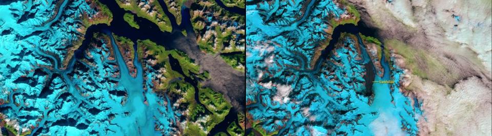
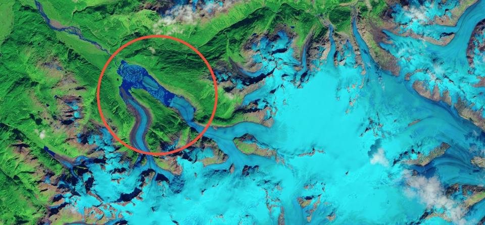
The first set of the picture represents the view of massive landslide called Glacier Bay National Park in Alaska having an equal mass of 60 million SUVs’. The landslide is dropping from a 4,000-foot altitude mountain precipice into the Lamplugh Glacier. While the before the image was clicked on 13th September 2015, the after view was taken on 7th August 2016.
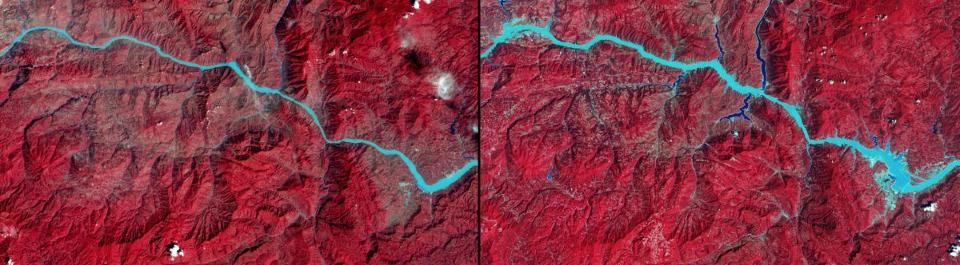
The second set represents the changing sights of the Three Gorges Dam. While the first image was taken September 1993, the newer one was framed in August 2016. The Three Gorges Dam was world’s biggest hydroelectric power plant when completed.
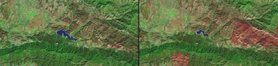
The third suite of an image describes the affected size of Lake Cachuma, California. The picture clicked October 2013 to October 2016 is giving the perfect examples of how the drought conditions in South California contributed changes in the total capacity of the lake.
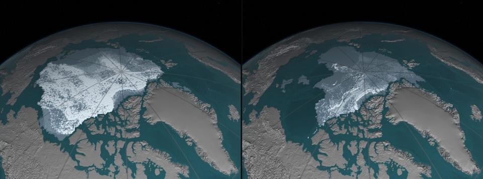
The fourth set is showing the mirror to the declining level of Arctic’s sea ice. The pictures, taken from September 1984 to September 2016 show how Arctic’s sea ice has dropped down from 718,000 square miles to 42,000 square miles between 1984 and 2016.
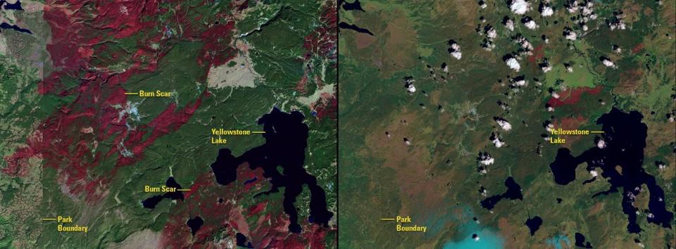
The images of the fifth suite of Series of Change, framed from October 1998 to June 2016 reveal how the large-scale fire events have been impacted some significant parts of Yellowstone National Park.
The sixth one consists of two before and after images, photographed in June 1984 and June 2016. The pictures are clearly representing the alterations in the Powder River Basin of Wyoming.
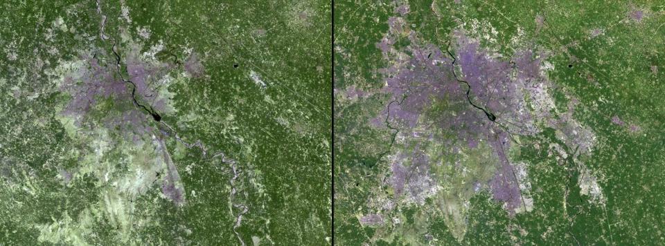
Series of Changes’ seventh image collection reveals the expansion of urban areas in New Delhi, India between March 1991 and March 2016. In this period, the population of New Delhi ballooned from 9.4 million in 1991 to 25 million in 2016.
The eighth set comprises of rising level of water in the Cedar River, Iowa. The pictures clicked on 8th July 2016 and 26th September 2016 shows how the excess rainfall swelled the water level of Cedar by 6 feet over its flood stage designation.
The ninth set shows how an eruption of European gypsy moth caterpillars herbicide the forests in Southern New England and the Mid-Atlantic province of the U.S. during the spring and summer season of the last year. Of two comparable images, one was clicked on 11th July 2015, while the second one was taken on 13th July 2016.
In the 10th image set, clicked on September 26, 2016, and October 12, 2016, respectively, NASA shows how Hurricane Matthew hampered southwestern Haiti.